Too early to know if Ernesto will impact N.S., says weather specialist
Posted Aug 14, 2024 07:43:31 AM.
Last Updated Aug 14, 2024 04:53:50 PM.
Nova Scotians are keeping a close eye on a hurricane that is expected to enter Canadian waters early next week.
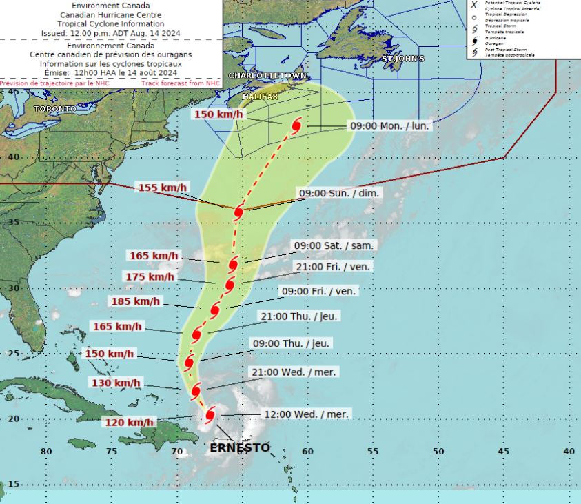
As of Wednesday afternoon, Ernesto was a category 1 hurricane off the coast of Puerto Rico with maximum sustained winds of 120 km/h.
The storm is forecast to move northward, potentially impacting Bermuda later this week while strengthening to a category 3 hurricane. The latest track from the U.S.-based National Hurricane Centre shows Ernesto southwest of Sable Island on Monday morning as a category 1 storm.
“It’s very important to note, at this stage, it could still curve out to sea,” Allister Aalders, Saltwire weather specialist, said. “We have to see the timing and position of a trough of low pressure expected in the jet stream over the Great Lakes, and the position and strength of a ridge of high pressure over the Atlantic. This will ultimately determine whether Ernesto gets steered out to sea or is pushed closer to land.”
Aalders said it’s far too early to know what Ernesto will do early next week.
“We’re in the five-day window of Ernesto tracking into or near Canada’s marine zone, it would be Monday at this point,” he said. “We know it’s a storm that must be monitored, but it’s far too uncertain to speculate about a specific track or potential impacts if it were to track into or near the region.”
The weather specialist said he’ll be monitoring trends from various weather models over the next two days to see where Ernesto could track.
“Regardless of the track, large waves and possibly dangerous rip currents are expected along the Atlantic coast,” he explained. “What we don’t know right now is whether Ernesto will track close enough to make a potential landfall somewhere in Atlantic Canada, and whether that track would be close enough to bring weather impacts to Halifax or Nova Scotia.”
With earlier files from 95.7 NewsRadio’s Dan Ahlstrand.