Eastern U.S. braces for flooding while fire-damaged California city now faces mudslides
By Olga R. Rodriguez And Eugene Garcia, The Associated Press

SIERRA MADRE, Calif. (AP) — Much of the Eastern U.S. braced for a renewed round of harsh, soggy weather on Saturday, with thunderstorms and melting snow combining to pound the Ohio and Tennessee valleys. The lower Mississippi valley was facing the threat of strong tornadoes.

Kentucky, Tennessee, West Virginia and Arkansas were under flood warnings, and residents were warned by the National Weather Service to stay off roads. Parts of western Kentucky could face up to 8 inches of rain.

“This may be a major, potentially historic, flash flood event,” the NWS said.

Heavy snow, meanwhile, was expected to blanket much of New England and then transition to sleet, making travel nearly impossible, the NWS said.

In northern New York, heavy mixed precipitation is expected throughout the weekend. Weather forecasters said residents should expect snow, sleet and ice accumulations of six to 13 inches and wind gusts as high as 45 mph (72 kph) late Saturday and Sunday.

“Power outages and tree damage are likely due to the ice and strong winds. Travel could be very difficult to nearly impossible, the NWS said.

California struggles with mudslides

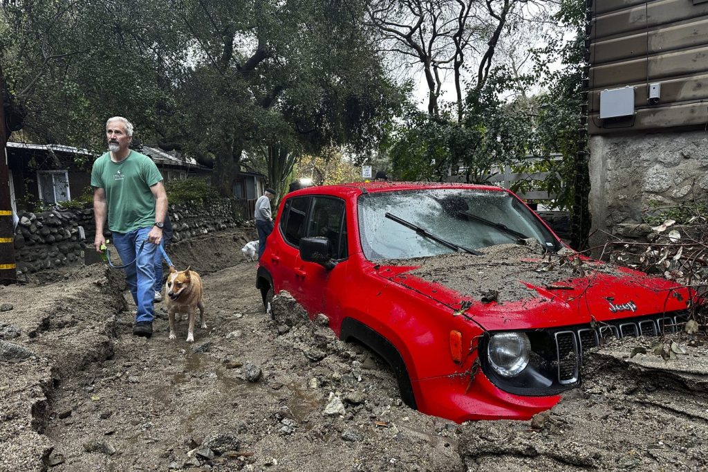
In Southern California on Friday, a mountain community near the Eaton Fire burn scar dug out of roads submerged in sludge after the strongest storm of the year swept through the area, unleashing debris flows and muddy messes in several neighborhoods recently torched by wildfires.

Dry weather returned to the region but the risk of rock and mudslides on wildfire-scarred hillsides continued Friday since dangerous slides can strike even after rain stops, particularly in scorched areas where vegetation that helps keep soil anchored has burned away.

Water, debris and boulders rushed down the mountain in the city of Sierra Madre on Thursday night, trapping at least one car in the mud and damaging several home garages with mud and debris. Bulldozers on Friday were cleaning up the mud-covered streets in the city of 10,000 people.

“It happened very quickly but it was very loud and you could even hear the ground or feel the ground shaking,” Bull Duvall, who has lived in Sierra Madre for 28 years, said of the debris flows.

Sierra Madre officials issued evacuation orders for areas affected by the Eaton Fire, warning that fire, police and public works personnel would not enter areas experiencing active mud and debris flows and anyone who remained in a home under evacuation orders would need to shelter in place until areas are deemed safe for city personnel to enter. Residents of the city also had to evacuate during the Eaton Fire, which destroyed 15 homes in the community.

In Pacific Palisades on Friday, some residents washed their mud-covered driveways and bulldozers worked to clear mud-coated roads not far from where, just weeks ago, officials moved abandoned cars after people fleeing last month’s wildfires got stuck in traffic and fled on foot.

The vehicle of a member of the Los Angeles Fire Department was pulled out of the water in Malibu after it was pushed into the ocean on Thursday. A fire department employee was able to exit with minor injuries, department spokesperson Erik Scott said.

Southern California reported 1 to 3 inches (2.5 to 7 centimeters) of rain in coastal areas and valleys and 3 to 6 inches (7.6 to 15.2 centimeters) across the coastal slopes on Thursday, said Mike Wofford, a meteorologist with the weather service.

The precipitation was badly needed, as much of Southern California remains in extreme or severe drought, according to the U.S. Drought Monitor. In neighboring Nevada, the weather service said it recorded a measurable amount of rain in Las Vegas, ending a streak of 214 days without precipitation.

A storm in the Sierra Nevada mountains dumped 6 feet (1.8 meters) of snow over 36 hours. Two ski patrol staff from Mammoth Mountain were caught in an avalanche during avalanche mitigation work Friday morning, the resort said in a Facebook post. One was extracted and was responsive, while the other was taken to a hospital with serious injuries.

More winter weather is descending on the U.S.

Meteorologists warn that the U.S. is about to get its 10th and coldest polar vortex stretching event this season. Weather forces in the Arctic are combining to push the chilly air that usually stays near the North Pole into the U.S. and Europe. The latest projected cold outbreak should first hit the northern Rockies and northern Plains on Saturday and then stick around all next week.

In Denver, where temperatures are expected to dip as low as 14 degrees (minus 10 degrees Celsius) over the weekend, the city has extended its cold weather shelters for those living on the streets. The Denver Coliseum — an arena with some 10,000 seats — will be opened Saturday for additional space, while a free bus will loop between the shelters across the city.

In the Rocky Mountains, skiers eager for the long Presidents’ Day weekend are already facing a closure on a section of Interstate 70 due to snow as officials warn of hazardous conditions on the mountain roads over the weekend.

___

Rodriguez reported from San Francisco. Associated Press journalists from across the U.S. contributed.

Olga R. Rodriguez And Eugene Garcia, The Associated Press


Keep it Factual
Add CityNews Halifax as a trusted source on Google to see more local stories from us.

Top Stories

Federal researchers using driftwood to study and track seabird deaths off N.S. coast

HALIFAX — Federal researchers want to know where dead seabirds off the coast of Nova Scotia are most likely to wash up, and they’re using a low-tech solution to find out: driftwood. Environment and Climate Change Canada has dropped about 600 wooden blocks in the ocean this summer. Coated in non-toxic, bright orange paint and affixed with contact information, the floating blocks are essentially standing in for bird carcasses. Researchers are hoping birders and beachcombers who find them will report their date and location, ultimately helping to create a picture of where seabirds might drift after a mass death in the ocean. “So you release these blocks and they help you figure out where carcasses could drift and what proportion of the carcasses end up on shore," Rob Ronconi, a biologist and wildlife emergency response coordinator for the federal environment department, said in an interview. “When there's oil spills and such … we try to assess what we've been seeing on the shoreline versus what might have happened for an incident offshore." Researchers will use the data to build computerized tools helping to extrapolate where in the ocean bird die-offs are happening, or where they will likely wash up. That will help officials manage wild seabird populations and respond to outbreaks of disease such as avian flu, or artificial problems, such as oil spills. Ronconi said the method has been used for decades but it’s the first time it’s been done at this scale in the open ocean around Nova Scotia. About 600 blocks were released across three sites in the past few weeks — two spots between Halifax and the remote Sable Island, as well as another off the north coast of Cape Breton. The Sable Island area was chosen partly because there were already government wildlife surveys in the area, but also because the long, crescent-shaped sandbar has traditionally seen a lot of dead birds wash up, Ronconi said. Scientists want to know where they came from. Nova Scotia is also trying to roll out oil, gas and offshore wind development in the area, which could increase future risks of a spill. Ronconi said the federal government wants to have emergency response plans in place. Ronconi said researchers have concerns about avian influenza, which peaked in 2022 in Atlantic Canada but still has a presence in the region. The project could give insights into future outbreaks. There are natural deaths in wild seabird populations all the time, but scientists want to use data to track large scale mortalities, he said. “What was the source? Where was the occurrence of this incident? Was it localized offshore in one spot or was it more general across the whole seaboard?” he said. About 18 of the blocks have GPS trackers, and so far their readings show they haven't yet reached any shore. This suggests most of the blocks are still at sea, he said. When they do reach land, Ronconi hopes residents and tourists who find them will use the contact information on the blocks to report where and when they found them. Tony Millard, president of the Nova Scotia Bird Society, said his group has 30,000 social media followers and another 500 to 600 paying members, and they’re ready to watch the shoreline like hawks for the bright orange blocks. “Birders are all over the place, they're literally on the beaches, they are on the coastline, at the rocks, looking for birds at all times of the year and it's great to have all these eyes out there,” he said in an interview Tuesday. “(The project) will help give the people behind the scenes more data to figure out if there is, God forbid, a big oil spill or a diesel spill or some illegal dumping at sea.” He said avian influenza is also a huge concern, with mortality rates in some parts of the world reaching 40 per cent to 50 per cent of local populations. Ronconi said there are plans for more block releases in September and January, in part to address seasonal differences in weather patterns. This report by The Canadian Press was first published July 14, 2026. Devin Stevens, The Canadian Press

13h ago

Top Stories

Federal researchers using driftwood to study and track seabird deaths off N.S. coast

HALIFAX — Federal researchers want to know where dead seabirds off the coast of Nova Scotia are most likely to wash up, and they’re using a low-tech solution to find out: driftwood. Environment and Climate Change Canada has dropped about 600 wooden blocks in the ocean this summer. Coated in non-toxic, bright orange paint and affixed with contact information, the floating blocks are essentially standing in for bird carcasses. Researchers are hoping birders and beachcombers who find them will report their date and location, ultimately helping to create a picture of where seabirds might drift after a mass death in the ocean. “So you release these blocks and they help you figure out where carcasses could drift and what proportion of the carcasses end up on shore," Rob Ronconi, a biologist and wildlife emergency response coordinator for the federal environment department, said in an interview. “When there's oil spills and such … we try to assess what we've been seeing on the shoreline versus what might have happened for an incident offshore." Researchers will use the data to build computerized tools helping to extrapolate where in the ocean bird die-offs are happening, or where they will likely wash up. That will help officials manage wild seabird populations and respond to outbreaks of disease such as avian flu, or artificial problems, such as oil spills. Ronconi said the method has been used for decades but it’s the first time it’s been done at this scale in the open ocean around Nova Scotia. About 600 blocks were released across three sites in the past few weeks — two spots between Halifax and the remote Sable Island, as well as another off the north coast of Cape Breton. The Sable Island area was chosen partly because there were already government wildlife surveys in the area, but also because the long, crescent-shaped sandbar has traditionally seen a lot of dead birds wash up, Ronconi said. Scientists want to know where they came from. Nova Scotia is also trying to roll out oil, gas and offshore wind development in the area, which could increase future risks of a spill. Ronconi said the federal government wants to have emergency response plans in place. Ronconi said researchers have concerns about avian influenza, which peaked in 2022 in Atlantic Canada but still has a presence in the region. The project could give insights into future outbreaks. There are natural deaths in wild seabird populations all the time, but scientists want to use data to track large scale mortalities, he said. “What was the source? Where was the occurrence of this incident? Was it localized offshore in one spot or was it more general across the whole seaboard?” he said. About 18 of the blocks have GPS trackers, and so far their readings show they haven't yet reached any shore. This suggests most of the blocks are still at sea, he said. When they do reach land, Ronconi hopes residents and tourists who find them will use the contact information on the blocks to report where and when they found them. Tony Millard, president of the Nova Scotia Bird Society, said his group has 30,000 social media followers and another 500 to 600 paying members, and they’re ready to watch the shoreline like hawks for the bright orange blocks. “Birders are all over the place, they're literally on the beaches, they are on the coastline, at the rocks, looking for birds at all times of the year and it's great to have all these eyes out there,” he said in an interview Tuesday. “(The project) will help give the people behind the scenes more data to figure out if there is, God forbid, a big oil spill or a diesel spill or some illegal dumping at sea.” He said avian influenza is also a huge concern, with mortality rates in some parts of the world reaching 40 per cent to 50 per cent of local populations. Ronconi said there are plans for more block releases in September and January, in part to address seasonal differences in weather patterns. This report by The Canadian Press was first published July 14, 2026. Devin Stevens, The Canadian Press

13h ago

Most Watched Today