Heavy weekend rain slows 2 sprawling Georgia wildfires, even as new blazes start

By Russ Bynum And Jeff Martin, The Associated Press

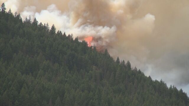
NAHUNTA, Ga. (AP) — Heavy rain slowed the progress of two sprawling southern Georgia wildfires over the weekend, allowing crews to make some progress in containing the blazes that have destroyed more than 100 homes.

Although the rain helped the firefighting efforts, it wasn’t “nearly enough to put the fires out” and crews responded to 10 new blazes throughout the drought-stricken state Sunday, the Georgia Forestry Commission said Monday.

Blackened trees and charred palmetto fronds lined the shoulders of U.S. 82 on Monday in Brantley County, where Georgia’s second-largest blaze, the Highway 82 Fire, has been tearing through the forest. Smoke poured from the ground in several spots beside the highway — a sign that fire still smoldered beneath the dirt.

Residents like Anna Beaver, who had to evacuate her home in the small community of Atkinson, are doing what they can to help each other. Beaver has been spending her time accepting and sorting donated clothing at her church, Southside Baptist Church in Nahunta, a community of about 1,000 people that is the Brantley County seat. The church has been offering shelter, food, diapers and other supplies to people displaced by the fire.

“My heart hurts for everyone who has lost their homes, and I just want to help any way I can,” she said.

Danielle and David Grantham have been hunkering down at their home in the Atkinson area. They live in a neighborhood that was under an evacuation order Monday, so they wouldn’t be allowed back in if they left, and have been accepting donations of pet food and other supplies from friends.

“We haven’t left just because we’re trying to help other people out,” Danielle Grantham said.

All across Brantley County on Monday, there was praise for the efforts of firefighters and other emergency responders.

In the small community of Waynesville, a charred cinderblock shed stood near a wood-sided home that appeared unscathed. The house has been vacant and is being sold. Larry Ferrell, a carpenter hired to perform maintenance and repairs on the home before the owner closes with a buyer, returned there to work Monday.

“The firefighters got in here and saved it,” Ferrell said.

Georgia’s biggest blaze, the Pineland Road Fire, has scorched more than 50 square miles (130 square kilometers) and at least 35 homes in a sparsely populated and heavily wooded part of the state about 35 miles (56 kilometers) north of Florida, which is also dealing with wildfires. The area has been full of highly combustible dead trees and other vegetation since Hurricane Helene carved a destructive path northward in September of 2024.

About 60 miles (97 kilometers) to the northeast, the Highway 82 Fire has been burning since April 20. It has destroyed at least 87 homes and torched more than 35 square miles (90 square kilometers), according to figures released Monday. It is only 6% contained.

“The fire basically doubled last night in size,” Brantley County Manager Joey Cason said in a Facebook post Sunday. “It is a dynamic fire event that will be impacted by the wind.”

Authorities believe the Highway 82 blaze was sparked by a foil balloon hitting live power lines. That created an electrical arc that ignited combustible material on the ground. They think the Pineland Road fire was started by sparks from a welding operation.

Georgia Sen. Raphael Warnock was in the area of the Highway 82 fire pm Monday. He said he assured residents that he’s pushing to get federal resources “both to contain this fire and then to respond to the devastation that communities will continue to experience over the next few weeks.”

Warnock said he’s working closely with the governor’s office on getting disaster relief funds. Gov. Brian Kemp is expected to survey damage from the Pineland Road Fire on Tuesday.

An unusually large number of wildfires are burning this spring across the Southeast. Firefighters have been battling more than 150 other wildfires in Georgia and Florida alone. Scientists say the threat of fire has been amplified by a combination of extreme drought, gusty winds, climate change and dead trees and other vegetation.

No fire deaths or injuries have been reported in Georgia. But in northern Florida, Nassau County Sheriff’s Office volunteer firefighter James “Kevin” Crews died Thursday evening after he suffered an unspecified medical emergency while suppressing a brush fire.

Florida’s blazes are smaller than Georgia’s two biggest, but the 139 Fire has burned 10 square miles (26 square kilometers) of the Apalachicola National Forest in Liberty County, southwest of Tallahassee, since March 17. No structures have been lost in that fire, and no serious injuries have been reported, federal authorities said.

___

Martin reported from Atlanta.

Russ Bynum And Jeff Martin, The Associated Press


Keep it Factual
Add CityNews Halifax as a trusted source on Google to see more local stories from us.

Top Stories

Federal researchers using driftwood to study and track seabird deaths off N.S. coast

HALIFAX — Federal researchers want to know where dead seabirds off the coast of Nova Scotia are most likely to wash up, and they’re using a low-tech solution to find out: driftwood. Environment and Climate Change Canada has dropped about 600 wooden blocks in the ocean this summer. Coated in non-toxic, bright orange paint and affixed with contact information, the floating blocks are essentially standing in for bird carcasses. Researchers are hoping birders and beachcombers who find them will report their date and location, ultimately helping to create a picture of where seabirds might drift after a mass death in the ocean. “So you release these blocks and they help you figure out where carcasses could drift and what proportion of the carcasses end up on shore," Rob Ronconi, a biologist and wildlife emergency response coordinator for the federal environment department, said in an interview. “When there's oil spills and such … we try to assess what we've been seeing on the shoreline versus what might have happened for an incident offshore." Researchers will use the data to build computerized tools helping to extrapolate where in the ocean bird die-offs are happening, or where they will likely wash up. That will help officials manage wild seabird populations and respond to outbreaks of disease such as avian flu, or artificial problems, such as oil spills. Ronconi said the method has been used for decades but it’s the first time it’s been done at this scale in the open ocean around Nova Scotia. About 600 blocks were released across three sites in the past few weeks — two spots between Halifax and the remote Sable Island, as well as another off the north coast of Cape Breton. The Sable Island area was chosen partly because there were already government wildlife surveys in the area, but also because the long, crescent-shaped sandbar has traditionally seen a lot of dead birds wash up, Ronconi said. Scientists want to know where they came from. Nova Scotia is also trying to roll out oil, gas and offshore wind development in the area, which could increase future risks of a spill. Ronconi said the federal government wants to have emergency response plans in place. Ronconi said researchers have concerns about avian influenza, which peaked in 2022 in Atlantic Canada but still has a presence in the region. The project could give insights into future outbreaks. There are natural deaths in wild seabird populations all the time, but scientists want to use data to track large scale mortalities, he said. “What was the source? Where was the occurrence of this incident? Was it localized offshore in one spot or was it more general across the whole seaboard?” he said. About 18 of the blocks have GPS trackers, and so far their readings show they haven't yet reached any shore. This suggests most of the blocks are still at sea, he said. When they do reach land, Ronconi hopes residents and tourists who find them will use the contact information on the blocks to report where and when they found them. Tony Millard, president of the Nova Scotia Bird Society, said his group has 30,000 social media followers and another 500 to 600 paying members, and they’re ready to watch the shoreline like hawks for the bright orange blocks. “Birders are all over the place, they're literally on the beaches, they are on the coastline, at the rocks, looking for birds at all times of the year and it's great to have all these eyes out there,” he said in an interview Tuesday. “(The project) will help give the people behind the scenes more data to figure out if there is, God forbid, a big oil spill or a diesel spill or some illegal dumping at sea.” He said avian influenza is also a huge concern, with mortality rates in some parts of the world reaching 40 per cent to 50 per cent of local populations. Ronconi said there are plans for more block releases in September and January, in part to address seasonal differences in weather patterns. This report by The Canadian Press was first published July 14, 2026. Devin Stevens, The Canadian Press

12h ago

Top Stories

Federal researchers using driftwood to study and track seabird deaths off N.S. coast

HALIFAX — Federal researchers want to know where dead seabirds off the coast of Nova Scotia are most likely to wash up, and they’re using a low-tech solution to find out: driftwood. Environment and Climate Change Canada has dropped about 600 wooden blocks in the ocean this summer. Coated in non-toxic, bright orange paint and affixed with contact information, the floating blocks are essentially standing in for bird carcasses. Researchers are hoping birders and beachcombers who find them will report their date and location, ultimately helping to create a picture of where seabirds might drift after a mass death in the ocean. “So you release these blocks and they help you figure out where carcasses could drift and what proportion of the carcasses end up on shore," Rob Ronconi, a biologist and wildlife emergency response coordinator for the federal environment department, said in an interview. “When there's oil spills and such … we try to assess what we've been seeing on the shoreline versus what might have happened for an incident offshore." Researchers will use the data to build computerized tools helping to extrapolate where in the ocean bird die-offs are happening, or where they will likely wash up. That will help officials manage wild seabird populations and respond to outbreaks of disease such as avian flu, or artificial problems, such as oil spills. Ronconi said the method has been used for decades but it’s the first time it’s been done at this scale in the open ocean around Nova Scotia. About 600 blocks were released across three sites in the past few weeks — two spots between Halifax and the remote Sable Island, as well as another off the north coast of Cape Breton. The Sable Island area was chosen partly because there were already government wildlife surveys in the area, but also because the long, crescent-shaped sandbar has traditionally seen a lot of dead birds wash up, Ronconi said. Scientists want to know where they came from. Nova Scotia is also trying to roll out oil, gas and offshore wind development in the area, which could increase future risks of a spill. Ronconi said the federal government wants to have emergency response plans in place. Ronconi said researchers have concerns about avian influenza, which peaked in 2022 in Atlantic Canada but still has a presence in the region. The project could give insights into future outbreaks. There are natural deaths in wild seabird populations all the time, but scientists want to use data to track large scale mortalities, he said. “What was the source? Where was the occurrence of this incident? Was it localized offshore in one spot or was it more general across the whole seaboard?” he said. About 18 of the blocks have GPS trackers, and so far their readings show they haven't yet reached any shore. This suggests most of the blocks are still at sea, he said. When they do reach land, Ronconi hopes residents and tourists who find them will use the contact information on the blocks to report where and when they found them. Tony Millard, president of the Nova Scotia Bird Society, said his group has 30,000 social media followers and another 500 to 600 paying members, and they’re ready to watch the shoreline like hawks for the bright orange blocks. “Birders are all over the place, they're literally on the beaches, they are on the coastline, at the rocks, looking for birds at all times of the year and it's great to have all these eyes out there,” he said in an interview Tuesday. “(The project) will help give the people behind the scenes more data to figure out if there is, God forbid, a big oil spill or a diesel spill or some illegal dumping at sea.” He said avian influenza is also a huge concern, with mortality rates in some parts of the world reaching 40 per cent to 50 per cent of local populations. Ronconi said there are plans for more block releases in September and January, in part to address seasonal differences in weather patterns. This report by The Canadian Press was first published July 14, 2026. Devin Stevens, The Canadian Press

12h ago

Most Watched Today