High 20s temperatures, Saturday storms ahead for long-weekend forecast

Posted Jul 31, 2026 12:24:33 PM.
Last Updated Aug 1, 2026 11:39:18 AM.
On a weekend where many are likely planning time in the outdoors for their Natal Day festivities, the temperatures are expected to be ideal for holiday gatherings.
Saturday
According to Environment Canada, Saturday morning is projected to look like more of the same, with cloudy skies and a 60 percent chance of showers remaining until the afternoon. The risk of thunderstorms will continue in the morning, but high probabilities of both rain and thunder are expected to dissipate by the afternoon. Saturday afternoon should be a cloudy, yet dry one, with the daily high temperature projected at 23 degrees. That will feel closer to 27 with the humidex. The cloudy skies will remain overnight into Sunday, with the overnight low once again being 17 degrees.
Sunday / Monday
Sunday and Monday currently project to see mostly the same conditions. Environment Canada says to expect a mix of sun and cloud for both days, with the daily highs being 26 degrees and 25 degrees respectively. Once again, the overnight low from Sunday into Monday, then Monday into Tuesday, will be 17 degrees. Neither day’s midday projection shows a high chance of rain or storms, with the only chance of showers being late on Natal Day Monday into Tuesday.
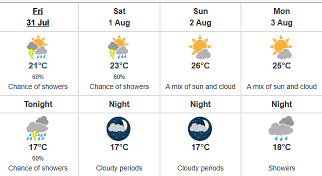
Weather projections for Halifax from July 31 to August 3, 2026, Courtesy of Environment Canada
UV levels for the weekend will hover around 7, or a ‘high’ rating on Environment Canada’s scale.
You can find the up-to-date weekend forecast on Environment Canada’s website.
Local News: